

Tenzin Nyidon
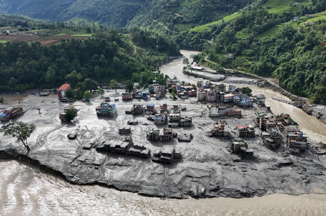
DHARAMSHALA, Aug. 29: The catastrophic flash flood that struck Nepal’s Rasuwa district on August 26, killing more than 600 people and leaving scores missing, has sparked fresh scrutiny of China’s expanding infrastructure footprint in occupied Tibet. Nepali journalists and analysts are raising questions about whether upstream construction and hydrological modifications along the Nepal-Tibet border may have intensified the disaster’s downstream impact.
A group of Nepali journalists has alleged that Chinese construction activities around Kyirong in occupied Tibet contributed to the ecological destabilisation that intensified the disaster. The group, operating through the Nepal Correspondence platform, claimed that the construction of settlements and infrastructure involved cutting into hillsides and altering the natural course of the Trishuli river system.
The journalists further alleged that the Kyirong border port was built near a river confluence in a way that could increase the velocity of water flowing towards Nepal. They described the development as an “ecological disaster” and called on the Nepali government to raise the issue with Beijing.
The claims have gained renewed attention following comments by Indian strategic affairs analyst Brahma Chellaney, who argued that the disaster should be understood through the distinction between its natural trigger and human-amplified consequences. In a statement posted on social media, Chellaney said the disaster was caused by a “natural trigger” involving a cryospheric collapse, but argued that Chinese hydrological modifications and infrastructure along the Tibetan side of the border may have amplified the severity and cascading effects downstream.
“China’s upstream actions did not cause the glacier failure but contributed to the disaster’s severity and cascading impacts,” he said. His assessment places the focus not on whether Chinese construction directly triggered the initial glacier collapse, but on whether modifications to rivers, drainage patterns, and mountain landscapes altered the scale or trajectory of the resulting flood.
Chellaney also criticised Beijing for what he said was a failure to provide Nepal with timely emergency information about sudden water-level surges, debris-dam formation, or other unusual upstream developments. He argued that an immediate warning could have prompted authorities to evacuate vulnerable communities and potentially reduced the loss of life.
The issue of early warning has assumed particular importance as the flood struck with extraordinary speed, sending a torrent of water, ice, mud, and boulders through downstream valleys. Reports have indicated that the Trishuli River rose dramatically within a short period, leaving little time for communities to respond.
Scientists have broadly linked the catastrophe to a glacier or ice-rock collapse in the Himalayan border region, although questions remain over the precise chain of events that preceded the flood. Recent reporting has also highlighted the growing vulnerability of high-altitude landscapes to climate change, permafrost degradation, and large-scale infrastructure development.
The Chinese government, meanwhile, has rejected allegations that its infrastructure or a failure to issue warnings was responsible for the disaster, maintaining that an earthquake or earthquake-like tremor triggered an avalanche and landslide that caused the flooding. The competing explanations have placed renewed scrutiny on the fragile and increasingly engineered Himalayan landscape, where glaciers, rivers, settlements, roads, and hydropower infrastructure intersect across national borders.
For Nepal, the disaster has also highlighted the vulnerability of downstream communities to events originating beyond its immediate control. The controversy has consequently revived calls for greater cross-border transparency, real-time hydrological data sharing, and a coordinated early-warning mechanism between Nepal and China.


China’s greeds at wills,
In the mountains it drills,
Roads,tunnels,dams in hills;
Now Ice🏔️on the top spills.
Stop fooling and leading Nepal into debt trap with loans for unsafe infrastructure developments for your own BRI agenda.
Compensate Nepal for the lives lost, properties and livelihood destroyed ! China is under moral obligation to rebuild Nepal. 🙏
————-
The heavy trade and transport infrastructure tied to Gyirong Port (Kyirong Port) forms the strategic anchor of the China-Nepal Economic Corridor, acting as the primary overland lifeline between Tibet and South Asia.
Belt and Road Initiative (BRI): The corridor serves as a core framework for bilateral cooperation between Beijing and Kathmandu under China’s broader global infrastructure strategy.
The primary trade and transport infrastructure elements include:
1. The China-Nepal Highway :
The Gyirong/Kerung Port Corridor: China has been building a heavily engineered, high-speed, multi-lane Highway extension into Nepal via the Gyirong crossing. This mega-project—featuring heavy tunneling and bridge construction—was targeted for broad completion by 2026.
2. The Shigatse–Kyirong Railway Project is a planned strategic railway under construction that will connect Shigatse to the border port town of Kyirong (Gyirong) near Nepal.
Route Length: Roughly 540 kilometers (336 miles).
3. Gyirong Port Infrastructure :
Directly across the border in Tibet’s Gyirong County, China has built extensive subterranean and transport networks:
-Underground Evacuation & Diverting Tunnels: China has constructed dozens of underground setups and interconnected tunnels near the Rasuwagadhi Valley to regulate transboundary river flow and feed into the Tibetan power grid.
4. The Trans-Himalayan Power & Tunnel Layout
Most of these projects are concentrated along the Bhote Koshi and Trishuli River basins, which originate in Tibet (as the Lhende River) and cut directly through the Himalayas into Nepal. This geographic funnel has been highly weaponized for “run-of-the-river” hydro setups, which rely heavily on massive underground water diversion tunnels rather than massive open-air reservoirs.
5. The Proposed Trans-Himalayan Railway Line.
-The Shigatse–Gyirong– Kathmandu Railway: Folded into the Trans-Himalayan Multi-Dimensional Connectivity Network under the Belt and Road Initiative.